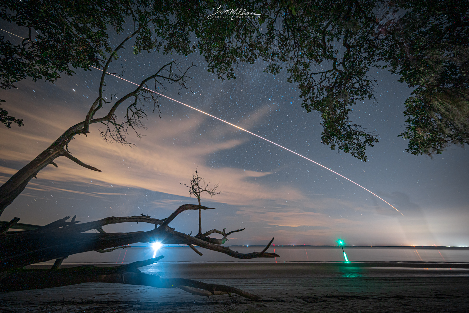
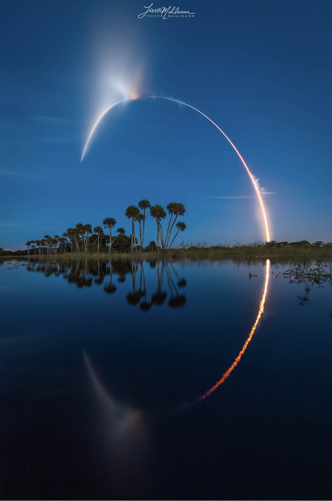
After launching from NASA’s Kennedy Space Center in Florida at 3:14 AM on August 29th delivering food, water, and new science experiments to the astronauts, on the morning of September 30th, at 9:13 AM Eastern Daylight Time — SpaceX’s 23rd Cargo Dragon undocked from the International Space Station, completed nearly 9 more orbits of the world, and then dipped back into the atmosphere to bring scientists and engineers the critical findings only experiments performed off Earth could yield.
This Cargo Dragon (C208) is the first of a new variant of Dragon spacecraft now being utilized to deliver supplies to the orbital outpost. Cargo Dragon 2 looks very similar to Crew Dragon, mainly without life support and the SuperDraco escape engines — but I am sure a litany of other changes. Both variants of Dragon now launch solely from LC-39A and can utilize the Crew Access Arm (CAA) for late-load cargo while vertical. This is a big upgrade from the previous iteration of Dragon, where the whole rocket would need to be brought back to horizontal to load/unload cargo.
Now, the photo!
The Ingredients For Success
- Google Maps / Street View
- FlightClub.io‘s Photographer’s Toolkit
- Past Cargo Dragon Reentry Shots
- Sugar
- Spice
- All Things Nice
More on FlightClub.io later, but without this tool, Declan’s work and collaboration together, continued photo dubs like this would not be possible.
The Photo
I surmised the idea to capture this photo only just a few days ago, when Dragon’s return timing and location were finalized as well as when weather in the general vicinity of splashdown and my various potential viewing sites were forecast to be generally clear.
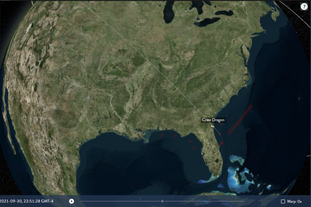
I began looking for viewing locations that initially lined up with an “ascending node” orbital trajectory, with a landing off the coast of Daytona Beach, Florida. After a bit of research, I learned that it was instead a “descending node” trajectory at the desired landing timeframe.
Now… it sounds complex at first, but explained more simply: ascending/descending node just means which direction it is coming from. Ascending going generally up/north, descending going generally down/south.
In the case of Crew Dragon and the Space Station (orbiting inclined 51.6 degrees) an “ascending node” means coming from a southwest direction, such as the Gulf of Mexico/Tampa/etc and traveling northeast, in CRS-23’s case toward Daytona.
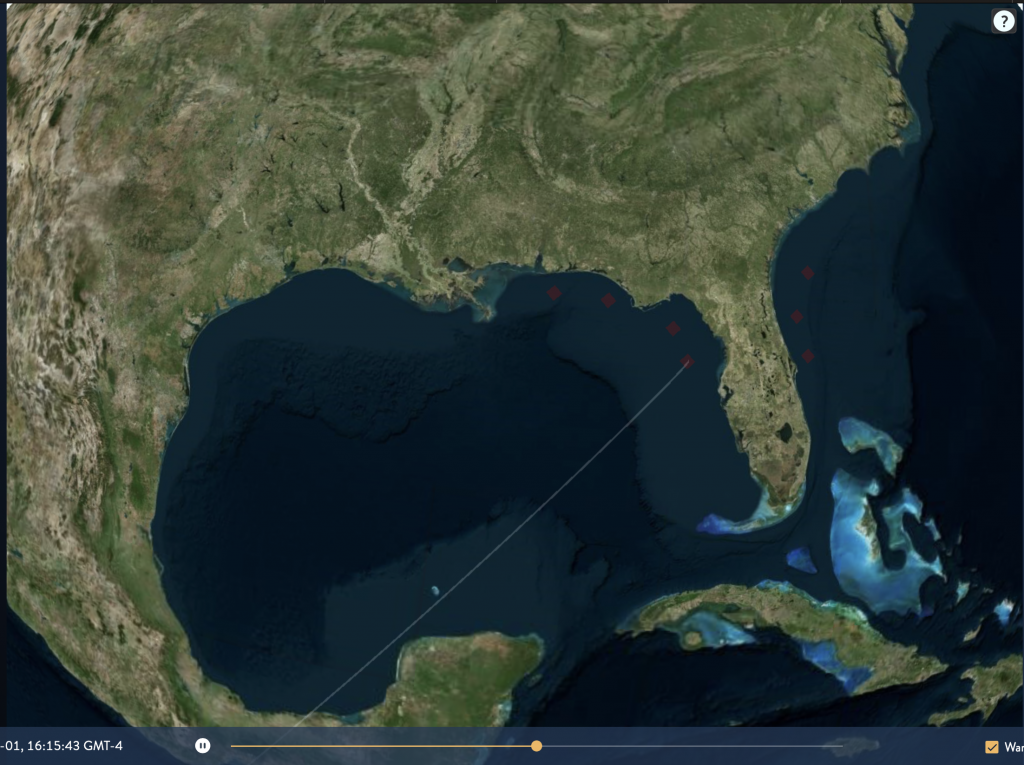
Inversely, if the orbital track is a “descending node” this means it is traveling from the northwest, in a southeast direction over places like Tennessee, northern Alabama, Georgia, and very northern Florida before landing off the coast of Daytona.
You can see more examples of descending nodes on the left (in the pacific west of the US/Mexico), and ascending in the middle here. (over Africa)

A major tool I use for both launches, landings, satellite passes, (and spacecraft reentries now) is called FlightClub. A good ol’ pal named Declan Murphy coded this beautiful piece of software, web-design, and technology and it is endlessly helpful for n00b photographers like me capture giant Ws.
CRS-23 was initially plotted in FlightClub as an ascending trajectory (remember: from the Gulf of Mexico) and after sorting that out — the planning could truly begin. (Otherwise I’d have been looking in the complete wrong portion of the sky🤣 Wouldn’t be the first time…🤫)
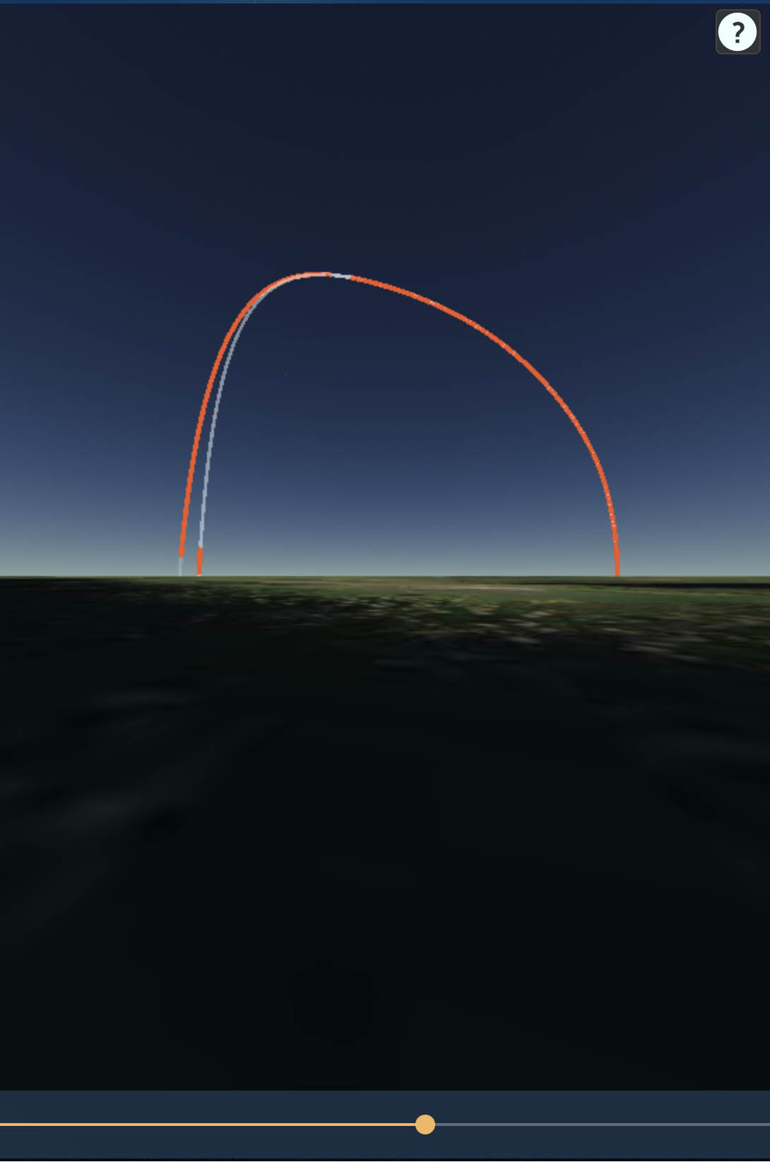
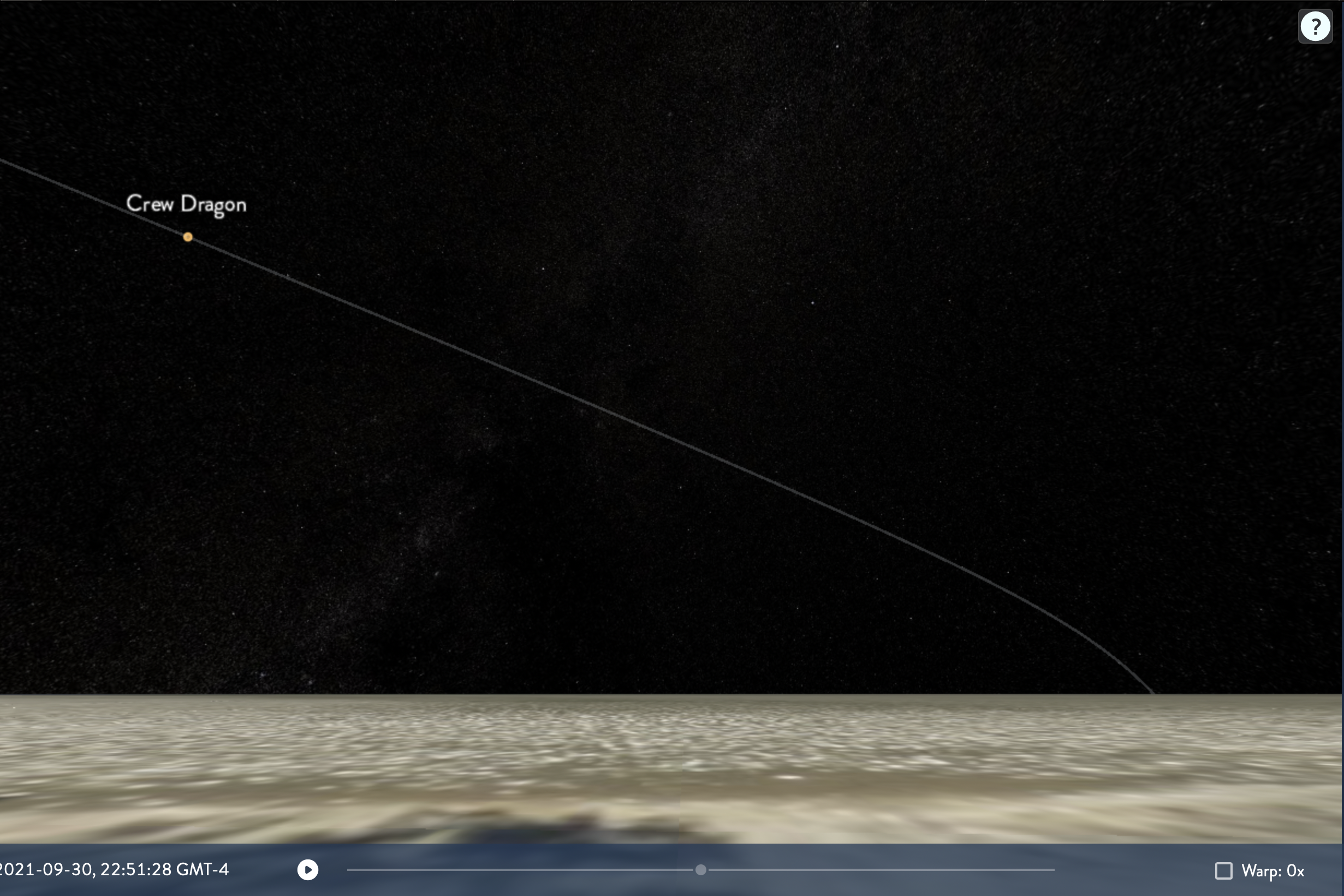
Specifically, FlightClub has a subset of features called the “Photographer’s Toolkit” where you plug in a GPS position, camera, lens focal length, and launch/satellite/reentry trajectories and out spits a three dimensional view (with star field, if night time) of what your photo could look like if you get the pointing, location, composition and prediction of the launch/satellite/reentry correct.
The hard part about this photo would be predicting where along the trajectory the “bright / red hot plasma” portion was going to be. I could get the general path of Dragon in a photo, that part is easy. The difficulty would come about in framing up the part of this path through a photo where it is specifically engulfed in plasma as it is reentering the atmosphere.
Yeah.
Cargo Dragon traveling nearly 5 miles per second, there is not much room for error here — if you miss by more than a few seconds, you could completely whiff an attempt at a specifically framed photo and it could translate to a big misstep because of how fast it was all going to happen.
So first, I needed to figure out this whole timing thing. I have plenty of rocket launches but no spacecraft reentries under my belt, so I had no prior knowledge to draw from for help other than the framing part. I had to look to previous captures of Dragon coming back from orbit to get a rough idea.
Enter: this wonderful capture of Cargo Dragon returning to Earth on CRS-21** (yes, I double checked this was actually CRS-21🤣) from Mat on Twitter.
Bonus: it has location information too! Perfect. This is all we needed for a rough guess at timing. Over to FlightClub we go.
The Pre-Plan
Mission: CRS-21 Return | Location: Shell Point Beach, Florida | Camera: Unknown, but ~4:3 roughly | Lens: Also Unknown but not needed
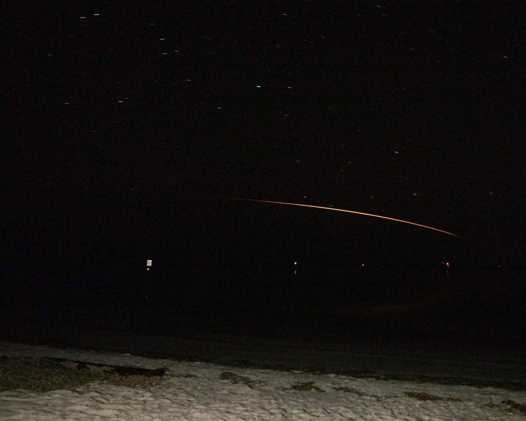
OK — great. Now I have rough confirmation that the prediction for the path FlightClub predicts Dragon returns to Earth from orbit, is roughly positionally correct. In this photo (looking south from the panhandle of Florida toward Tampa) Cargo Dragon is traveling right to left as time goes on.
Now for the timing.
I set out to find timestamps for 5 variables/data points:
- First Light (first time it is visible)
- Fade To Distinguishable (when it reaches steady state brightness)
- Peak Brightness (capsule == maximum dummy hot)
- Begin Fade Out (fading from steady state brightness)
- Invisible (bai bai Dragon, GL w landing)
Having these 5 points in time would tell me when to start and how long to potentially be prepared to expose for.
FlightClub doesn’t model parachutes (yet?…Mr Declan?) but it does have a set time in which it thinks “splashdown” will be. So, I figure out those points out relative to that splashdown time. Sort of like if splashdown were a launch, and I want to find a bunch of “T Minus” times. With splashdown being zero/liftoff, for example.
Even though it is not correct to when the capsule really splashes down, it doesn’t matter for the reentry photo. Dragon can have crazy cool parachutes that make it take forever to actually land/super softly, but the reentry will still look the same.
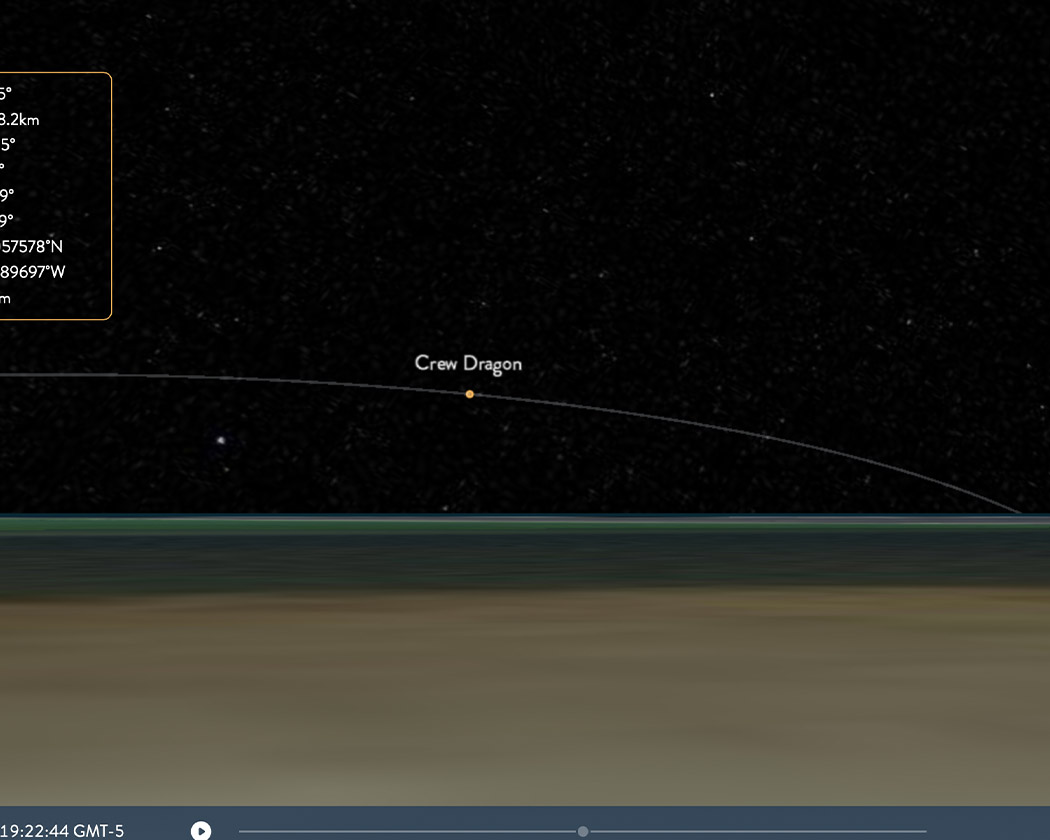
So from FlightClub, I figure out all my “S Minus” (CRS-21 splashdown minus) times:
FlightClub 21 Splashdown: 19:24:54
First light: 19:21:41 (21S-3min13sec) | Downrange distance: 343mi
Fade to distinguishable: 19:21:51 (21S-3min3sec)
Peak Brightness: 19:22:28 (21S-2min26seconds)
Begin Fade out: 19:22:35 (21S-2min19sec)
Invisible: 19:22:44 (21S-2min10sec)
I also calculated as a sort of verification/checksum/mental sanity item: the downrange distance from splashdown to the ground point below where First Light is. So take Cargo Dragon at First Light up at like 40-50km, go down to zero altitude/ocean surface, how far is that away from the splashdown location? 343 miles, got it. Will keep that in mind just to make sure my CRS-23 times aren’t off by a crazy amount.
Now with my “S Minus” times for CRS-21 (assuming these are roughly the same for every Dragon return) I just needed to work backwards from Flight Club’s predicted “splashdown” time for CRS-23’s return to find out what actual time in real life those “S Minus” times corresponded with on the 30th of September.
Haven’t lost you yet — have I?
If nothing else: here’s a cookie for making it this far 🍪
The Plan (CRS-23 this time)
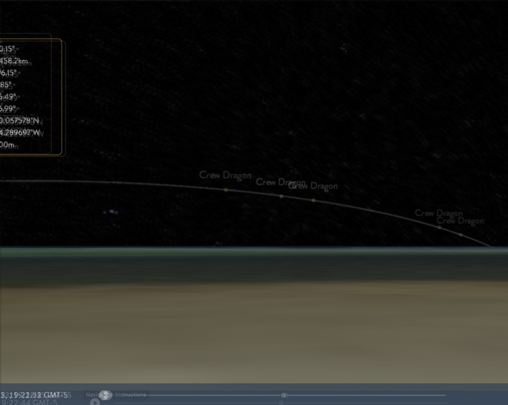
My “S Minus” times will remain the same, all that will change is the actual real life times: both the predicted splashdown time in FlightClub (even though incorrect) and my lighting predictions on the left.
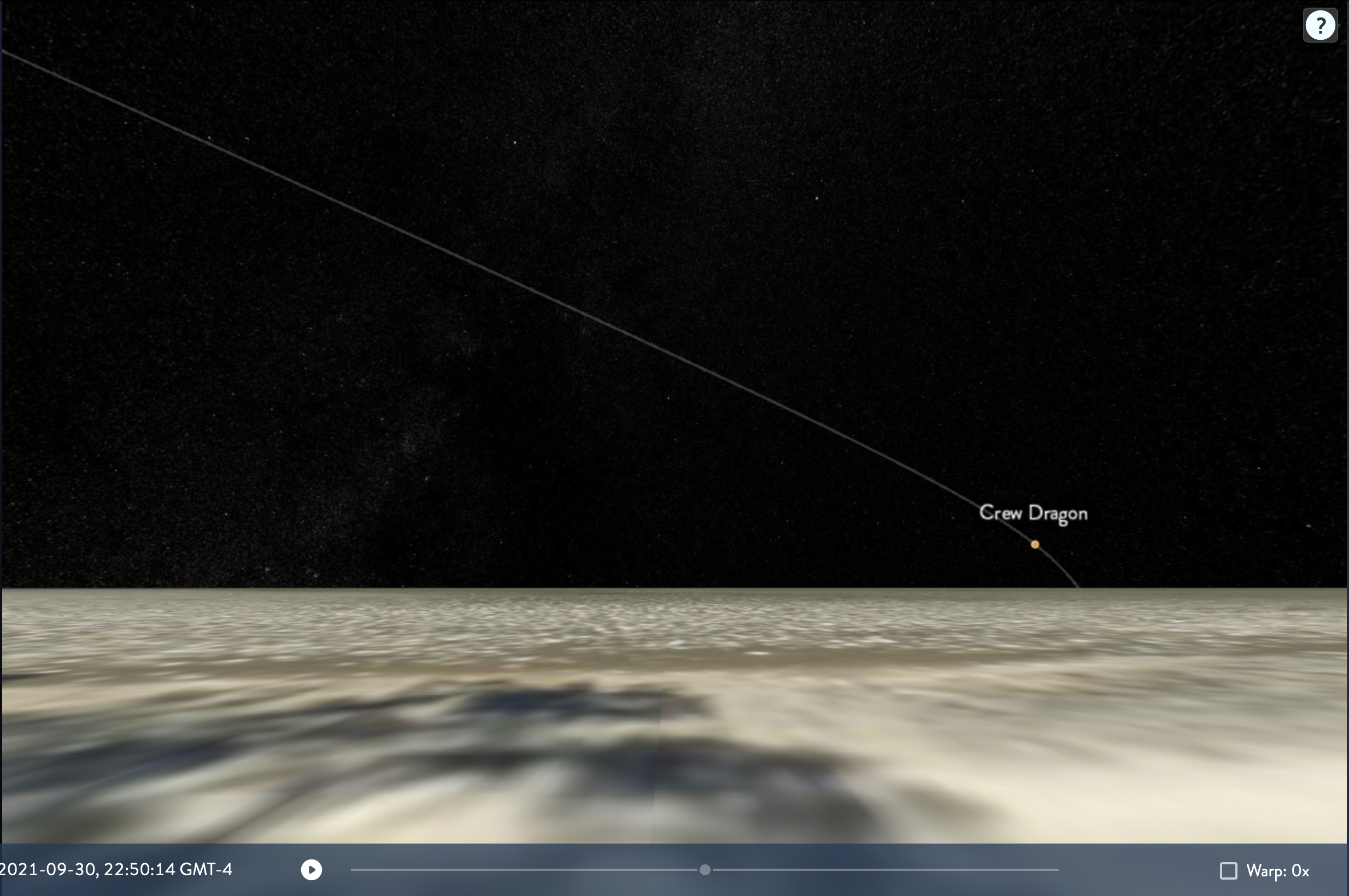
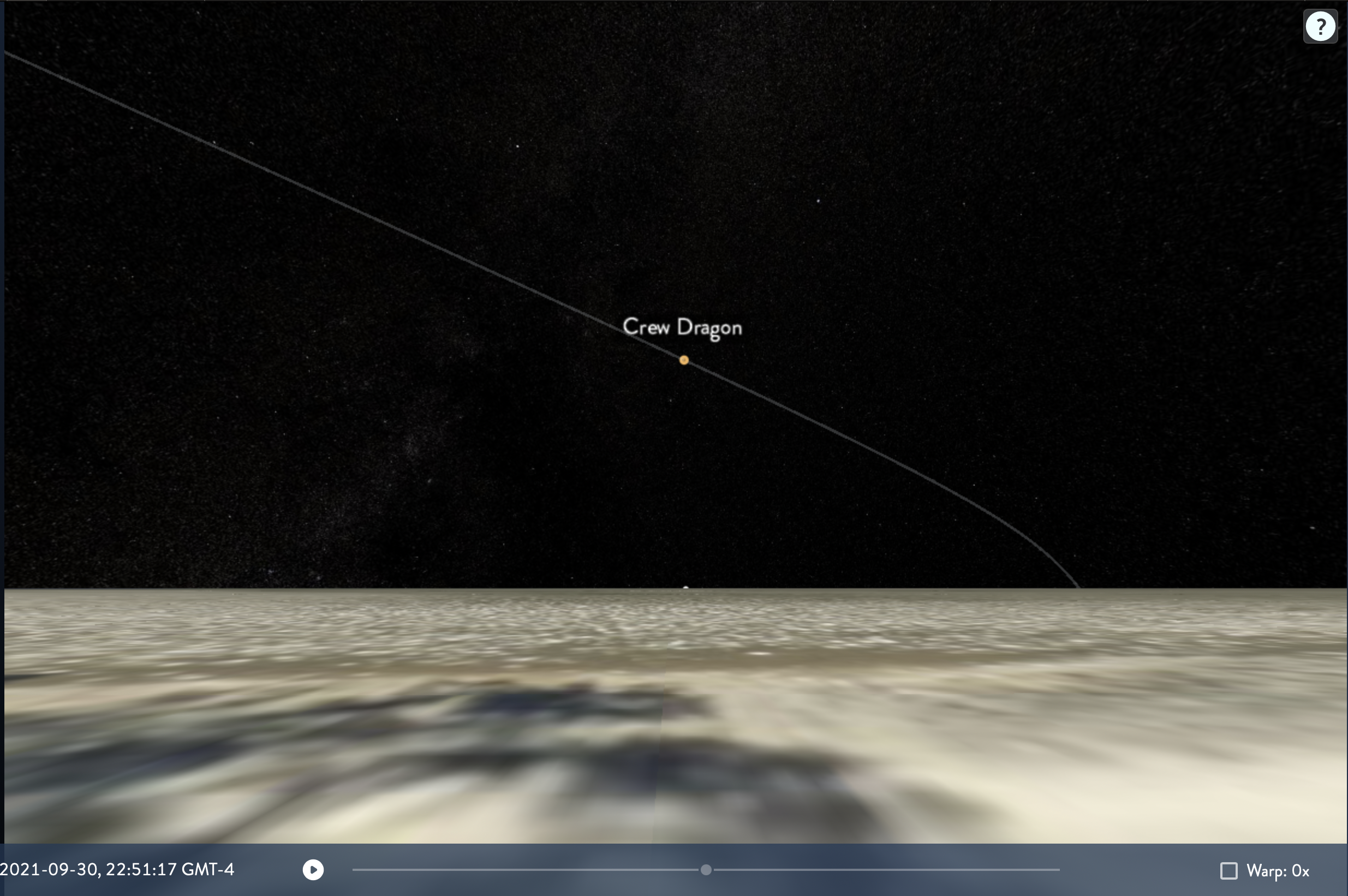
FlightClub 23 Splashdown: 22:53:27
First light: 22:50:14 (23S-3min13sec) | Downrange: 347 mi
Fade to distinguishable: 22:50:24 (23S-3min3sec)
Peak Brightness: 22:51:01 (23S-2min26seconds)
Begin Fade out: 22:51:08 (23S-2min19sec)
Invisible: 22:51:17 (23S-2min10sec)
343 miles is close to 347 miles for First Light downrange distance, bingo.
All these numbers are great, but what do they mean? How do these help you?
This means at 10:50:14pm Eastern Time on Sept 30, that is when capsule should become illuminated. and at 10:51:17pm — it will fade out to black and back into the cover of night.
This helps me, because now I can go and plan in and out points for a photo. Here is what I ended up with.
I plugged in my potential location: Brunswick, Georgia
Camera: Full Frame Canon (1:1, no crop factor)
Lens: 11mm
Here is the framing and what that gave me.
The Cargo Dragon would fade in in the lower right, then peak between there and fade out by frame center, with potentially a little bit of Milky Way or stars in there in the upper left. But with lots of room left in that upper left corner for it to keep burning bright if it does stay lit for longer. (foreshadowing)
The Shot
Now, for the results.
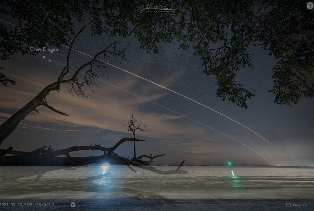
I thought Dragon would be visible between 10:50:14 and 10:51:17pm (~63 seconds) shown in the side by side above.
It ended up being easily visible for almost exactly double that: 10:49:30 to 10:51:35. Slightly earlier by ~45 seconds than initial First Light prediction and almost a minute longer than my initial Invisible prediction, taking it well through the upper left corner of my frame but that’s ok — my first time attempting this and a great starting place!
I even stepped into my own frame while recording a video on my phone before realizing, moving quickly, but still leaving a slight ‘ghost’ in the long exposure — and somehow perfectly framed over Dragon’s trail.
Prediction overlaid onto the real photo. Dragon passed out of frame ~10:51:29.
So completely thrilled with this result, and the fact that I’ve got a group of people supporting me on a regular basis that allow me to dive head first with two full days of my time into the depths of planning out a photo like this and making sure I flesh out all potential issues with it — resulting with what you see.
Without them, cliche to say, but I just couldn’t do that. If you enjoyed this post and would like to become a Patron of mine, helping me capture more awesome stuff like this, and write out/record more awesome bts stories like this you can do that here! https://www.patreon.com/trevormahlmann Thank you!! See you next time for another photo!
If you’d like a print of any of the photos in this post, you can find those here: https://www.tmahlmann.com/photos/ and likely under “Recent Photos” most easily! 😀
The Plan | The Shot

Leave your email below to keep up-to-date with the latest in spaceflight! (A few emails a month, max.)